I’m glad that you’ve come to learn more about my series on landscape change in San Francisco.
Please find all paintings below with detailed descriptions, and my statement on the works underneath.
Use the arrows to navigate between paintings.
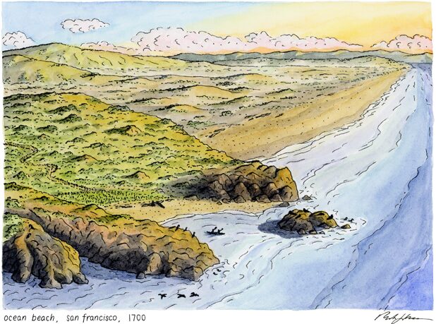
“OCEAN BEACH” IN 1700
For at least 10,000 years, people have inhabited the San Francisco Bay Area. The Yelamu tribe of the Ramaytush Ohlone, with a seasonal camp near the cliffs at the north end of Ocean Beach, may have regularly visited this area, and intentionally managed the land.
Vast sand dunes spread from the hills to the coastal rocky cliffs and inlets. Distant ranges are visible on the horizon, with a mix of grassland and oak woodland dotting the closer slopes. Pelicans and sea lions thrive at seal rock and the shore environment.
Sea level gradually rose 400 feet to its present level since the last glacial maximum 18,000 years ago, and has been stable for the past 3,000 years.
Do you recognize this view?
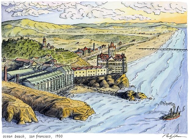
“OCEAN BEACH” IN 1900
By 1900, Settler-colonists transformed the landscape into a location of leisure, as an escape from the rapidly urbanizing city of San Francisco. The 200 years since 1700 witnessed the arrival of the Spanish missions and colonists, and the rapid decline of the Ramaytush Ohlone due to enslavement in the coercive mission system, and disease.
There was a brief period of Mexican independence, followed by the continued legacy of the United States’ settler-colonization after the U.S. Intervention in Mexico (to satisfy the expansionist ambitions of U.S. leaders). Elites and farmers were first to venture to these “outside lands,” followed by visitors upon Sutro’s construction of the second cliffhouse, Sutro Baths, and gardens. Entertainment was built along the beach, a pier was constructed to support a pipe which conveyed seawater to downtown baths, and the landscaping of Golden Gate Park had begun.
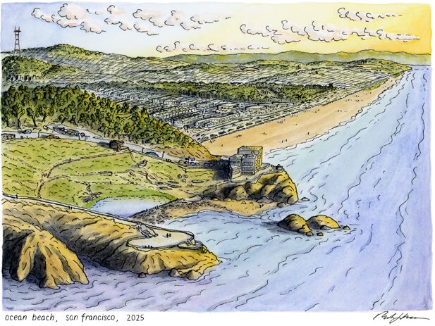
“OCEAN BEACH” IN 2025
Perhaps you now recognize more features of this landscape. What in the painting helped orient you? In the years since 1900, the victorian-style cliffhouse burned down and was rebuilt modestly, and the Sutro Baths met a similar fiery fate in the 1960s after decreased popularity and a short period as a skating rink. A collection of highrise condos were almost built here, but the city abandoned the project, and this land was eventually incorporated into the Golden Gate National Recreation Area (GGNRA). Sutro Heights endured a period of neglect before also being incorporated into the GGNRA. The city more fully developed Golden Gate Park, and reshaped the sand dunes for housing. In the distance, you’ll see that TV and radio interests erected Sutro Tower for improved signals, and the city built the “Great Highway” and seawall along the beach. The Ramaytush Ohlone continue to call this land home. Take a moment to reflect on how this land has changed since 1700. Who made these changes?
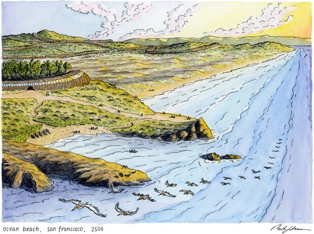
“OCEAN BEACH” IN 2500
What comes to mind when you envision a future for San Francisco? In several centuries, what will take the place of our current buildings and bridges? How might our relationship with nature manifest itself?
In this vision, humans have built collective housing with centralized services, well inland of potential sea level rise. Their presence on the land is rooted in connection to the local landscape and the ecosystem of which they’re part. The dunes returned after relocation.
This is just one vision.
What would you like to see in the future of this place?

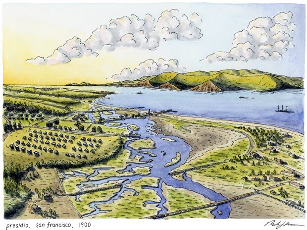
“PRESIDIO” IN 1700
After the San Francisco Bay finished “filling” about 3,000 years ago, a sand spit developed with a tidal slough behind it, fed by springs along the northern peninsula.
The sun sets on another day, and the Yelamu tribe of the Ramaytush Ohlone prepare for night at their winter village of Petlenuc, at the site of present-day Presidio.
A careful eye will discern the Yelamu village and a group of people navigating the estuary. The brackish waters extend between the hills and the spit, with the un-bridged golden gate in the distance. Rolling coastal scrub and prairie land is dotted by live oak woodland, managed by the Ramaytush Ohlone with regular burning, and abundant tideflats fill and drain each day.
Did you know there was an estuary here?
“PRESIDIO” IN 1900
In the two centuries after the snapshot of 1700, the Spanish missionaries and colonists arrived, enslaving the indigenous Yelamu and Ohlone peoples throughout the Bay Area onto missions. Violence, poor conditions, and disease led to a sharp reduction in their population at the hands of the Spanish. Of the original Ramaytush Ohlone population of 1500 to 2000 persons, only a few families survived the Mission Period. The Spanish established the Presidio as a military fort (to guard against other colonizing countries and exert control over their claims), with the grounds continuing to exist into the Mexican period, and with the United States. The Presidio remained an active military property through 1900 and well beyond. In 1900, it operated as a base for U.S. soldiers leaving for, and returning from, the Spanish American War in the Philippines, as the U.S. continued its imperial conquests. Farmers worked east of the military boundary, and settlers began to fill the tideflats. Can you imagine where the Golden Gate Bridge might be built in a few decades?
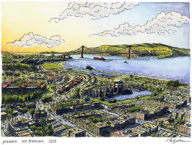
“PRESIDIO” IN 2025
Here we find a familiar landscape – the Golden Gate Bridge, with a large ship leaving for the Pacific. The U.S. Military continued their operation of the Presidio through both world wars, until 1994 when it was transferred as surplus to the Golden Gate National Recreation Area. In 2001, “restored” open spaces were revealed to the public. The Golden Gate Bridge spanned the passage of the same name in 1937. The Palace of Fine Arts was erected as a temporary structure as part of a 1915 exposition, and was eventually rebuilt in 1967. Farmland gave way to housing, a small tidal lagoon has been restored, and the distant Marin Headlands are dotted with the legacy of WWII fortifications. Though there are no known living persons with direct ties to the independent Yelamu tribe, members of other tribes (Aramai and Chiguan) of the broader Ramaytush Ohlone peoples continue to care for their shared ancestral homeland, and all beings who inhabit this land. What feelings arise when you compare this scene to the landscapes of 1900 and 1700?
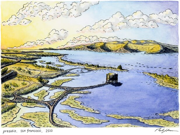
“PRESIDIO” IN 2500
Sea levels have risen fifteen feet in 500 years, and human presence on the land has been reshaped to include inland housing structures.
Walkways criss-cross the shoreline and parts of the inlet made by rising seas, with a path to a “palace of fine arts.” (Surely the present-day palace would not last to 2500, but I include it to make an easy visual comparison with a well known landmark).
The Golden Gate Bridge no longer spans the passage, and other creatures share a home with humans on this northern stretch of the peninsula.
How do you feel when you imagine this future? How will we need to change, in order to meet a future that allows both the Earth and humans to flourish?
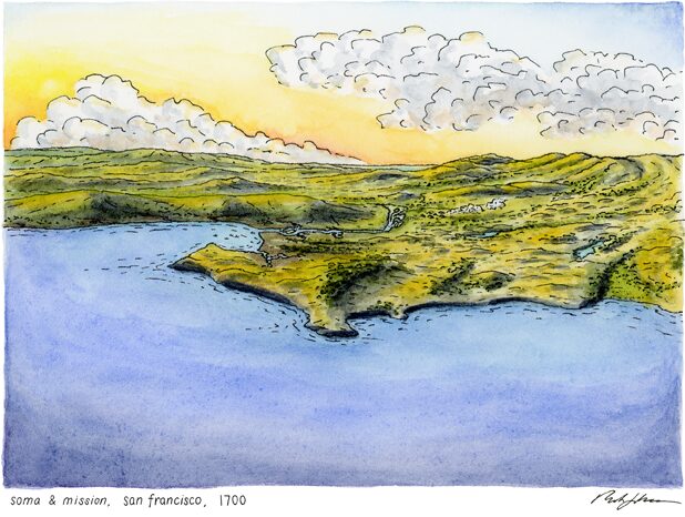
“SOMA AND MISSION” IN 1700
“Mission Bay” is calm at the end of another day in 1700, with a narrow tidal inlet leading into what will become today’s Mission District.
The summer village, Chutchui, of the Yelamu tribe of the Ramaytush Ohlone, is located just uphill from the inlet. Can you see the village? Also within this scene, but not shown, is the second village of Sitlintac. The Yelamu regularly used controlled burns to manage the landscape.
The landscape is a mix of sand dunes, freshwater springs and ponds, prairie, and oak woodlands. Marshes and wetlands are plentiful and are teeming with abundance.
Are you able to imagine what this view looks like today?
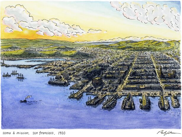
“SOMA AND MISSION” IN 1900
In a short time… a landscape transformed. The Spanish established a mission near the Yelamu village of Chutchui and proceeded to cause the deaths of more than 5,000 indigenous people from the region over several decades, through enslavement, poor conditions, and disease.
After the U.S. assumed control of California following the period of Mexican independence, the gold rush led to a surge in development. Developers and the city moved sand dunes, transformed plank roads into city blocks, and filled the bays to create new real estate.
The cove (front right in 1700) is completely filled, aided by the rotted ships abandoned by gold seekers. New piers were built, and notable buildings include the marine hospital (center) and the Selby Shot Tower (at center right) for making ammunition. A railroad crosses Mission Bay, and the hills are only just beginning to be developed. How do these changes to the landscape make you feel?
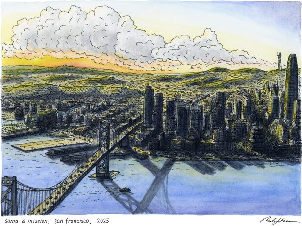
“SOMA AND MISSION” IN 2025
Again, a dramatic reshaping. Shadows fall differently on a city of towers. Mission Bay has since been fully filled and built upon, and following the 1906 earthquake and fire, the city has been rebuilt and transformed over decades, leading to today’s tech skyscrapers forming a silhouette of downtown. In face of this monumental change, members of the Ramaytush Ohlone continue to inhabit this land, working toward a better future.
The bay bridge opened in 1936 and juts into the city at Rincon Hill, and the city’s central hills have been covered with homes. A close eye can make out the rectangular slope of Mission Dolores Park, Sutro Tower, and the radio towers on San Bruno Mountain. Take a moment to compare this scene to the one shown in 1700, and notice where the bay and coves are buried in today’s world.
Where do you think the sea will go when it rises?
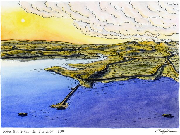
“SOMA AND MISSION” IN 2500
Nearly five centuries later, and again, San Francisco is barely recognizable.
With higher sea levels, the shoreline has receded and humans resettled into long, integrated communal structures. Mission Bay has returned with rising seas, and a long pier rests on the old bay bridge foundations to offer boat transport across the bay. Much of the landscape is restored or used for sustainable agriculture, with the hills once again populated by scrub, chaparral, and grassland. How would you imagine this scene differently? What is your hopeful vision for the future of San Francisco? If you notice yourself having some feelings of loss and grief — comparing today’s image and the future — investigate why that is. How would we need to change to be in closer relationship with the land? What in our culture needs to shift, to be relearned/reframed, in order to realize the benefits that are possible if we give up some of the practices and things we hold familiar?
Artist Statement
When was the last time you considered the past life of the land beneath your feet?
Or it’s future?
Do you consider the appearance of the landscapes you encounter daily as static, or as an ever-evolving canvas, reflecting our relationship with the land?
How do you relate to the Earth that sustains us?
With “Ever-changing: A Story of San Francisco and its People,” I take my curiosity of “what was before?” and “what might be?,” and visualize it. For three different locations on the peninsula, I paint the landscape as it likely appeared in 1700 and 1900, its current state today (2025), and a possibility for the distant future (2500).
As you view the pieces, take some moments to notice what emotions you experience.
Loss? Grief? Hope? Fear? Unease? Gratitude?
What about the paintings make you feel that way?
The alterations to the landscape speak for themselves, showing us how a place can change at the hands of humans. And while these changes since colonization have been predominantly harmful to the health of the Earth and its intertwined systems, I believe that the scale of haphazard development illustrates a similar capacity for intentional restoration.
We have in our hands the capability to build a future presence on this Earth that reflects values of sustainability, reciprocity, and respect, when we internalize that we are an extension of the land, not separate.
For the paintings set in 2500, I don’t expect you to agree with my vision. I often have difficulty holding hope for an optimistic future, considering the challenges we currently face and the trajectory our elected officials and corporate lords seem determined to force upon us, especially now. It has been the teachings of dear professors, and the writings of cultural visionaries, that have opened my world and influenced my perspective – Robin Wall Kimmerer’s Braiding Sweetgrass is particularly potent in my conscience.
With encouragement from these inspiring teachers, I challenged myself to imagine a future where we “get it right” (see Ayana Elizabeth Johnson) — where we build inland from rising seas, share collaborative and collective housing, concentrate our impact on the Earth to a smaller footprint, and live with a reciprocal relationship to the land and the other beings of this Earth. While these painted visions present one of many possible outcomes, and are of my own imagination, it is my hope that the efforts toward our future presence on this Earth are led by Indigenous communities and those who share similar worldviews. Locally, that includes the first stewards of San Francisco, the Ramaytush Ohlone, who have tended to this place for millennia. To achieve this vision requires structural transformation, including to our economic system. And, prerequisite and perhaps most importantly, there must be a cultural shift toward collectivism and reciprocity with the Earth — a task toward which this collection of work aims to contribute. Certainly the visions laid out here for the future are idealistic, and yet I believe that we must hold a vision of hope if we wish to make a change in that direction.
What feelings come up when you consider these future visions?
Spend some time to ponder what “getting it right” means to you.
I could have included more snapshots in time, either before 1700 (showing geological change and the shaping of land by the indigenous Ramaytush Ohlone), or intermediate steps (showing a more continuous picture of development by colonizers). I selected these dates for my own capacity as an artist, and to best illustrate the drama of the most significant changes. Indigenous stewards of the land certainly changed the landscape, through burning practices, shellmounds, and their village sites. The scale of these changes are not obvious on the scale of my paintings, and simultaneously illustrate one of my intended sentiments – that these minglings with the land were not crudely violent, nor to the scale of those wrought by the Spanish, Mexican, nor the continued legacy of American settler-colonists.
Change is inherent. There is no stasis within ourselves, nor the extended world around us. May we recognize these transformations and acknowledge our capacity to change for better. At the root of this aspiration for an intentional relationship to land, is the necessity of paying attention.
With viewing this series, it is my hope that you may begin, or continue to, pay attention to changes in the world around you. As Kimmerer beautifully writes, “paying attention is a form of reciprocity with the living world, receiving the gifts with open eyes and an open heart.”
On Sources: The 1700 and 1900 scenes were painted with intentional effort to adhere to historical accuracy, in consultation with historical surveys, maps, and photographs. The photo archives available at opensfhistory.org were particularly helpful in this effort of historical visualization. Imaginings of the 1700 landscapes were assisted by a publicly available map: Hidden Nature SF, crafted by the San Francisco Estuary Institute.